
 Golinhac
Golinhac
Golinhac
[Golinhac]
From its perch up on the plateau, Golinhac overlooks the steep sides of the Lot gorges. In the 10C and 11C, the village was a viguerie, an administrative district where a viguier [vicaire] or judge meted out justice. The priory was attached to Conques abbey in 1097. Throughout the feudal period, Golinhac would be an important place for the local lords.
In the 16C, it fulfilled a pivotal role, with an administrative function (collection of censives, annual duties paid to the lord), craftworking, two fairs and a mass on Sunday that attracted flocks of country people. This prosperity would last up until the middle of the 20C. Around 1940, the village boasted 8 cafés!
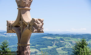
The pilgrims' cross (15C), known as the cross dels roumious, is an important landmark on the route to Santiago de Compostela. Sculpted out of sandstone, it is decorated with a Virgin and Child and on its base there is a small pilgrim holding his bourdon or staff.
The cross on display is a copy dated 2014; the original one is kept inside the church. It is the showpiece of a really interesting tour of crosses that has been organised on the initiative of the Foyer Rural community hall (see map).
Where do all these names ending in ‘ac’ come from?
Golinhac, Castailhac, Espeyrac, Campuac, etc. This ending in '-ac' points to the Celtic (Rouergue used to be the territory of the Ruteni tribe) or Gallo-Roman origin of an estate.
The Celtic suffix '-acos', meaning 'domain of' subsequently changed to Latin in the form '-acum'.
Must-sees
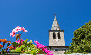
The pre-Romanesque church, modified in the 14C and covered with rooms used as refuge in the 15C.
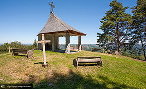
The lake which is a welcome stopping place. Notre Dame des Hauteurs, its stations of the cross and its viewpoint
Facilities for you
Between Aubrac and Conques, the local authorities of the area that the Puy en Velay route to Santiago de Compostela (GR®65) runs through have carried out a series of developments to help you discover this pedestrian and cultural route that is laden with meaning and history. Information boards line the 80 km section of the route. They will provide you with the tools to discover the heritage that is visible from the route (Romanesque monuments, landscape, geology, rural life, etc.)
A multimedia application (to download free of charge to smartphones and tablets - see below) helps to guide you and give you information about services (accommodation, food, visits, etc.).
You will find extra information on the elements to discover.
Facilities have also been designed for the safety and well-being of users: picnic areas, waterless toilets, footpaths alongside roads, signposts, path maintenance, etc.
The GR® and how to use it
The greatest care is taken to maintain the route and to welcome you in our villages so that the walk is a pleasant one for you. Nevertheless, you are responsible along the way.
Please take your rubbish away with you. There are lots of litter bins and toilets along the route.
The best way to observe nature is to respect it (no loud noises or shouting, avoid walking in big groups, etc.). Do not pick flowers, do not disturb the wildlife and herds of livestock. Respect fencing and private property.
Even on foot, please abide by the Highway Code. Warning: in foggy weather, some routes may be dangerous. Start when the fog has lifted or walk along the side of the roadway.
The route is a way to open up to nature, the life of the inhabitants and the traditions and history of the towns and villages you go through: the people of Aveyron invite you to share their convivial way of life, be curious and feel free to talk to the people you meet!
Information: Entraygues sur Truyère Tourist Office: 05 65 44 56 10 / Web : www.tourisme-entraygues.com
Comité Départemental du Tourisme de l’Aveyron (Aveyron Tourist Board) : www.tourisme-aveyron.com


